Mount Padang: Difference between revisions
| Line 6: | Line 6: | ||
== Geological Formation == | == Geological Formation == | ||
[[File:GPR.jpg|400px|thumb|right| | [[File:GPR.jpg|400px|thumb|right|Archaeologists propose that there is more beneath the surface than what we know]] | ||
The mountain | The mountain | ||
== Discovery == | == Discovery == | ||
Revision as of 21:28, 15 November 2019
What Is It?

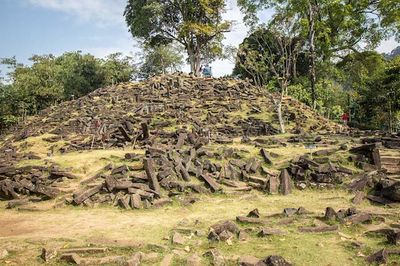
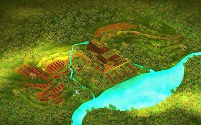
Mount Padang, which is sometimes also referred to as Gunung Padang, is a 300 foot step pyramid that is located in a small village called Karyamukti, on the island of Java. The island of Java is split up into five separate provinces: East, Central, and West Java, as well as Banten, and the Special Region of Yogyakarta. Mount Padang resides in the province of West Java. The name "Mount Padang" roughly translates to Mountain of Light, or Mountain of Enlightenment.[1] Because the top of the mountain is covered in large stone slabs, that makes Mount Padang a megalithic site. The site of Mount Padang is known to be the largest megalithic site known to man in all of South East Asia.[2] Megalithic sites are sites that are constructed using large stones to make monuments, typically for religious reasons, and sometimes for political leaders of a civilization. What sits at the top of the mount is what most people know Mount Padang for, which is largely still a mystery to archaeologists of today. The mountain is covered in grass, trees, and many other forms of vegetation, and with a large spiral of stones sitting on the top. In its known history, the area was used as a place for relaxation and meditation.[1] Those who live around the mountain have always known that to be the case, and that its purpose was only for relaxation. Mount Padang's use is not overly known, which has lead pseudo-archaeologists to try and answer that question for us. The site has been excavated once over the year of 2014, and several surveys have been conducted that tell archaeologists, and even geologists what lie beneath the surface.
Geological Formation

The mountain
Discovery
Originally discovered in 1914 by Dutch colonists. It first appeared in publications from a man named Rapporten van de Oudheidkundige Dienst, in the "Report of the Department of Antiquities."[3] It was then mentioned again in 1949 in a work by a Dutch Historian, N. J. Krom.[3] The Dutch have had a long standing colonization of Indonesia, and more specifically the island of Java, where Mount Padang sits. The Dutch were interested in colonizing this island after the collapse of the Dutch East Indies, so as to set up a new and successful administration here. Java was the main focus for the Dutch, as it was determined the other islands of Indonesia would not profit the Dutch like Java would. This area endured many years of war between those who wanted to take control of the land, and those who were indigenous to the island of Java. Because of the Spice Route and the spices found within the islands of Java, the Dutch were obviously very interested in obtaining the control of this area.[4] It was not until 1979 that archaeologists finally "discovered" it for themselves. At this time, the National Archeology Research Centre began to start observing this site and being
Pseudo Deconstruction of Mount Padang
- ↑ 1.0 1.1 https://www.sott.net/article/271881-Gunung-Padang-The-lost-records-of-Atlantis
- ↑ https://www.globalindonesianvoices.com/17286/megalithic-sites-in-indonesia/
- ↑ 3.0 3.1 http://www.andrewcollins.com/page/articles/gp.htm
- ↑ https://theindoproject.org/a-brief-history-of-the-dutch-east-indies-part-1/