Mount Padang: Difference between revisions
No edit summary |
No edit summary |
||
| Line 2: | Line 2: | ||
[[File:Mountpadang.jpg|470px|thumb|right|Mount Padang, Indonesia. Archaeological Site]] | [[File:Mountpadang.jpg|470px|thumb|right|Mount Padang, Indonesia. Archaeological Site]] | ||
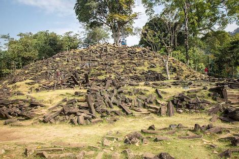
Mount Padang, which is sometimes also referred to as Gunung Padang, is a 300 foot step pyramid that is located in a small village called Karyamukti, on the island of Java. The island of Java is split up into five separate provinces: East, Central, and West Java, as well as Banten, and the Special Region of Yogyakarta. Mount Padang resides in the province of West Java. The name "Mount Padang" roughly translates to Mountain of Light, or Mountain of Enlightenment.<ref name=hancock>https://www.sott.net/article/271881-Gunung-Padang-The-lost-records-of-Atlantis </ref>Because the top of the mountain is covered in large stone slabs, that makes Mount Padang a megalithic site. The site of Mount Padang is known to be the largest megalithic site known to man in all of South East Asia.<ref>https://www.globalindonesianvoices.com/17286/megalithic-sites-in-indonesia </ref> Megalithic sites are sites that are constructed using large stones to make monuments, typically for religious reasons, and sometimes for political leaders of a civilization. What sits at the top of the mount is what most people know Mount Padang for, which is largely still a mystery to archaeologists of today. The mountain is covered in grass, trees, and many other forms of vegetation, and with a large spiral of stones sitting on the top. In its known history, the area was used as a place for relaxation and meditation.<ref name=hancock/>Those who live around the mountain have always known that to be the case, and that its purpose was only for relaxation. Mount Padang's use is not overly known, which has lead pseudo-archaeologists to try and answer that question for us. The site has been excavated once over the year of 2014, and several surveys have been conducted that tell archaeologists, and even geologists what lie beneath the surface. | Mount Padang, which is sometimes also referred to as Gunung Padang, is a 300 foot step pyramid that is located in a small village called Karyamukti, on the island of Java. The island of Java is split up into five separate provinces: East, Central, and West Java, as well as Banten, and the Special Region of Yogyakarta. Mount Padang resides in the province of West Java. The name "Mount Padang" roughly translates to Mountain of Light, or Mountain of Enlightenment.<ref name=hancock>Hancock, G. (2014, January 10). Gunung Padang: The lost records of Atlantis?. In Gunung Padang: The lost records of Atlantis?https://www.sott.net/article/271881-Gunung-Padang-The-lost-records-of-Atlantis </ref>Because the top of the mountain is covered in large stone slabs, that makes Mount Padang a megalithic site. The site of Mount Padang is known to be the largest megalithic site known to man in all of South East Asia.<ref>https://www.globalindonesianvoices.com/17286/megalithic-sites-in-indonesia </ref> Megalithic sites are sites that are constructed using large stones to make monuments, typically for religious reasons, and sometimes for political leaders of a civilization. What sits at the top of the mount is what most people know Mount Padang for, which is largely still a mystery to archaeologists of today. The mountain is covered in grass, trees, and many other forms of vegetation, and with a large spiral of stones sitting on the top. In its known history, the area was used as a place for relaxation and meditation.<ref name=hancock/>Those who live around the mountain have always known that to be the case, and that its purpose was only for relaxation. Mount Padang's use is not overly known, which has lead pseudo-archaeologists to try and answer that question for us. The site has been excavated once over the year of 2014, and several surveys have been conducted that tell archaeologists, and even geologists what lie beneath the surface. | ||
=== What Does it Look Like? === | === What Does it Look Like? === | ||
| Line 19: | Line 19: | ||
== Pseudo Narrative of Mount Padang == | == Pseudo Narrative of Mount Padang == | ||
Many people who offer pseudo explanations of Mount Padang, often use it to link it to the existence of Atlantis, or some other elevated civilization.<ref name=mystery>http://mysteriousuniverse.org/2014/01/gunung-padang-and-the-lost-city-of-atlantis/</ref> Whether this theory is to poke fun at the literal elevation of Mount Padang or because it seems like the likely explanation, there are still a lot of holes left behind that do not quite tell us the whole truth. To truly understand the pseudoarchaeological narrative of Mount Padang, we must incorporate the importance of Plato. Plato is a Greek philosopher, who is known to have produced the dialogues of 'Timias and Critias.'<ref name=hancock/>The '''Timias and Critias''' are the first time that there is any mention of of a civilization more advanced than ours, that being Atlantis. By general agreement, it is accepted that Plato is correct when he says Atlantean's emerged somewhere around '''9,600 BCE.'''<ref name=hancock/>The (pseudo) scientists who have done testing on Mount Padang have linked these two relative dates to perhaps be the same civilization. If Atlantean's are supposed to be around 9,600 BCE, and there are radiocarbon dates to around '''10,000 BCE,''' then by all means the science and chronology somewhat link up to each other. The placement of Mount Padang in the Indonesian islands also coincides with some scientists theories that Atlantis was somewhere in the Java Sea area.<ref name=atlantis>https://atlan.org/evidences-of-indonesian-atlantis-location/</ref> Author of Atlantis: The Lost City is in Java Sea, Dhani Irwanto concluded that after 5 years of analytical research, the story of Atlantis being placed in the Java Sea/Indonesian area does fit the puzzle.<ref name=atlantis>https://atlan.org/evidences-of-indonesian-atlantis-location/</ref> People like Graham Hancock are convinced this might be the illusive Hall of Records from Atlantis. | Many people who offer pseudo explanations of Mount Padang, often use it to link it to the existence of Atlantis, or some other elevated civilization.<ref name=mystery>http://mysteriousuniverse.org/2014/01/gunung-padang-and-the-lost-city-of-atlantis/</ref> Whether this theory is to poke fun at the literal elevation of Mount Padang or because it seems like the likely explanation, there are still a lot of holes left behind that do not quite tell us the whole truth. To truly understand the pseudoarchaeological narrative of Mount Padang, we must incorporate the importance of Plato. Plato is a Greek philosopher, who is known to have produced the dialogues of 'Timias and Critias.'<ref name=hancock/Hancock, G. (2014, January 10). Gunung Padang: The lost records of Atlantis?. In Gunung Padang: The lost records of Atlantis?>The '''Timias and Critias''' are the first time that there is any mention of of a civilization more advanced than ours, that being Atlantis. By general agreement, it is accepted that Plato is correct when he says Atlantean's emerged somewhere around '''9,600 BCE.'''<ref name=hancock/Hancock, G. (2014, January 10). Gunung Padang: The lost records of Atlantis?. In Gunung Padang: The lost records of Atlantis?>The (pseudo) scientists who have done testing on Mount Padang have linked these two relative dates to perhaps be the same civilization. If Atlantean's are supposed to be around 9,600 BCE, and there are radiocarbon dates to around '''10,000 BCE,''' then by all means the science and chronology somewhat link up to each other. The placement of Mount Padang in the Indonesian islands also coincides with some scientists theories that Atlantis was somewhere in the Java Sea area.<ref name=atlantis>https://atlan.org/evidences-of-indonesian-atlantis-location/</ref> Author of Atlantis: The Lost City is in Java Sea, Dhani Irwanto concluded that after 5 years of analytical research, the story of Atlantis being placed in the Java Sea/Indonesian area does fit the puzzle.<ref name=atlantis>https://atlan.org/evidences-of-indonesian-atlantis-location/</ref> People like Graham Hancock are convinced this might be the illusive Hall of Records from Atlantis. | ||
Revision as of 18:57, 2 December 2019
What Is It?

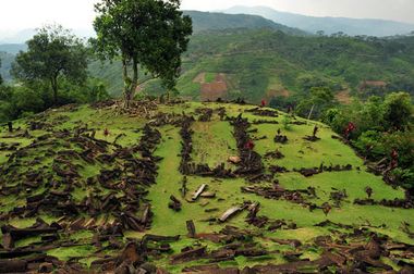
Mount Padang, which is sometimes also referred to as Gunung Padang, is a 300 foot step pyramid that is located in a small village called Karyamukti, on the island of Java. The island of Java is split up into five separate provinces: East, Central, and West Java, as well as Banten, and the Special Region of Yogyakarta. Mount Padang resides in the province of West Java. The name "Mount Padang" roughly translates to Mountain of Light, or Mountain of Enlightenment.[1]Because the top of the mountain is covered in large stone slabs, that makes Mount Padang a megalithic site. The site of Mount Padang is known to be the largest megalithic site known to man in all of South East Asia.[2] Megalithic sites are sites that are constructed using large stones to make monuments, typically for religious reasons, and sometimes for political leaders of a civilization. What sits at the top of the mount is what most people know Mount Padang for, which is largely still a mystery to archaeologists of today. The mountain is covered in grass, trees, and many other forms of vegetation, and with a large spiral of stones sitting on the top. In its known history, the area was used as a place for relaxation and meditation.[1]Those who live around the mountain have always known that to be the case, and that its purpose was only for relaxation. Mount Padang's use is not overly known, which has lead pseudo-archaeologists to try and answer that question for us. The site has been excavated once over the year of 2014, and several surveys have been conducted that tell archaeologists, and even geologists what lie beneath the surface.
What Does it Look Like?

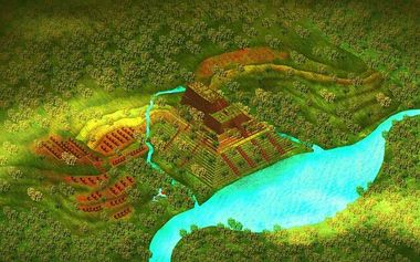
The whole mountain top is separated into five terraces. It resembles a Step Pyramid like that of Djoser's in Saqqara, except it is covered in vegetation. The construction on each of them is relatively the same, which suggests that one culture constructed the whole megalithic site. Some people believe that this site was actually a combination of a few different civilizations. Each terrace is connected by a stone stairway, with pillars all the way to the top. From bottom to top, there is a total of 370 steps, which puts the top of Mount Padang at an elevation of 960 meters above sea level.[3] All five terraces are placed relatively in front of each other so they are somewhat level with one another. All of the stones and pillars look to be elaborately placed, with some forming room like structures and entrances. Aerial imaging shows this clearly, that perhaps at some point this was a mountain covered in rooms. There is no evidence that suggests there were ever roofs though, which leads to the theory of open air sanctuary or place of worship.
Geological Formation

The mountain was originally a volcano, with a chamber of lava, or magma beneath its surface. Geologists and other scientists have dated the mountain to be from the Tertiary period, which puts its age somewhere between 66 million to 2.6 million years ago. This time frame is quite large, and assigning an "age" to something not alive is not entirely necessary for just a mountain that is no longer a volcano. However, it is important to know a relative date in terms of figuring out this megalithic site in an archaeological context. This will at least tell us who was around/alive and could have potentially interacted with the mountain. There are multiple layers that compose the entirety of the mountain, each with varying depths. Of the four layers that exist, the fourth one sits at the bottom, and is also the deepest. The fourth layer is about 15 to 20 meters think, and is the remnants of the volcano that existed prior. It is composed of andesitic basalt rocks and has not been modified by humans. Beneath the fourth layer is a void, or a tube, that scientists do not know much about. The second and third layer have about the same depths, but have been modified by humans. It is
Discovery
Originally discovered in 1914 by Dutch colonists. It first appeared in publications from a man named Rapporten van de Oudheidkundige Dienst, in the "Report of the Department of Antiquities."[3] It was then mentioned again in 1949 in a work by a Dutch Historian, N. J. Krom.[3] The Dutch have had a long standing colonization of Indonesia, and more specifically the island of Java, where Mount Padang sits. The Dutch were interested in colonizing this island after the collapse of the Dutch East Indies, so as to set up a new and successful administration here. Java was the main focus for the Dutch, as it was determined the other islands of Indonesia would not profit the Dutch like Java would. This area endured many years of war between those who wanted to take control of the land, and those who were indigenous to the island of Java. Because of the Spice Route and the spices found within the islands of Java, the Dutch were obviously very interested in obtaining the control of this area.[4] It was not until 1979 that archaeologists finally "discovered" it for themselves. At this time, the National Archeology Research Centre began to start observing this site and being
Pseudo Narrative of Mount Padang
Many people who offer pseudo explanations of Mount Padang, often use it to link it to the existence of Atlantis, or some other elevated civilization.[5] Whether this theory is to poke fun at the literal elevation of Mount Padang or because it seems like the likely explanation, there are still a lot of holes left behind that do not quite tell us the whole truth. To truly understand the pseudoarchaeological narrative of Mount Padang, we must incorporate the importance of Plato. Plato is a Greek philosopher, who is known to have produced the dialogues of 'Timias and Critias.'Cite error: Invalid <ref> tag; invalid names, e.g. too many Author of Atlantis: The Lost City is in Java Sea, Dhani Irwanto concluded that after 5 years of analytical research, the story of Atlantis being placed in the Java Sea/Indonesian area does fit the puzzle.[6] People like Graham Hancock are convinced this might be the illusive Hall of Records from Atlantis.
Danny Natawidjaja PhD. who holds the title 'senior geologist' at the Research Center for Geotechnology at the Indonesian Institute of Sciences, explained to Graham Hancock:
“The geophysical evidence is unambiguous,” Natawidjaja says. “Gunung Padang is not a natural hill but a man-made pyramid and the origins of construction here go back long before the end of the last Ice Age. Since the work is massive even at the deepest levels, and bears witness to the kinds of sophisticated construction skills that were deployed to build the pyramids of Egypt or the largest megalithic sites of Europe, I can only conclude that we’re looking at the work of a lost civilization and a fairly advanced one."[5] The work that Dr. Natawidjaja has done on Mount Padang is enough to convince himself and Graham Hancock, a pseudoarchaeological giant, that some higher civilization had to have played a part in the construction of the site.
An anonymous writer from Ancient Code explains the content found within the hill:
"One of the most interesting things about Gunung Padang, aside from its age, is that during coring it was found that much of the buried structure was reinforced with a type of cement. This bonding agent, which has been used as a mortar and sort of glue in certain parts of the site, consists of 45% iron ore, 41% silica and 14% clay. It’s said that this mixture provides for a very strong and durable mortar base, and is surprising evidence of the level of sophistication of the building techniques, used during construction"[7] This is surely to be a sign that our ancient ancestors had no way of knowing how to construct and use materials themselves.
Deconstructing the Pseudoarchaeological Narrative
Recent geo-electric dating in 2012 has revealed something that geologists had never really understand about the mountain: the megalithic site does not just sit on the top of the hill, it is the whole hill itself.[5] Stated before, the entirety of Mount Padang is composed of chambers in four different layers. Ground Penetrating Radar has solved the mystery of what lies beneath the ground, but excavations have been halted for the simple reason that they do not know what lays there. Some archaeological techniques might damage/interfere with something that lies below. Excavations are hopefully to resume when archaeologists and government officials agree on how to move forward. Regardless of what lies beneath, structures or something else, it seems that science has allowed us to understand that Mount Padang is old, thanks to core drillings. Samples from the hill have uncovered evidence that suggests the mountain is a multi-leveled structure, one phase being built on top of the next.[3] This leads some to believe that it was not just one civilization that built constructed this whole site, but perhaps a few. Building over what their ancestors or predecessors left behind. Desril Riva Shanti, the head of Bandung Archaeological center has expressed that the excavations at Mount Padang are not executed in a proper way. Some fo the first few people who excavated the land were not archaeologists at all, rather Indonesian soldiers. The use of soldiers over archaeologists was in some ways an economic move by the government, however, their
The team recently announced traces of a civilization from 5200 BC, estimated to be older than the civilization responsible for building the Egyptian pyramids.
The site at Mount Padang is believed to be a large terraced tomb, which takes first place as the biggest megalithic culture in the Indonesian archipelago.[8]
References
- ↑ 1.0 1.1 Hancock, G. (2014, January 10). Gunung Padang: The lost records of Atlantis?. In Gunung Padang: The lost records of Atlantis?https://www.sott.net/article/271881-Gunung-Padang-The-lost-records-of-Atlantis
- ↑ https://www.globalindonesianvoices.com/17286/megalithic-sites-in-indonesia
- ↑ 3.0 3.1 3.2 3.3 http://www.andrewcollins.com/page/articles/gp.htm
- ↑ https://theindoproject.org/a-brief-history-of-the-dutch-east-indies-part-1/
- ↑ 5.0 5.1 5.2 http://mysteriousuniverse.org/2014/01/gunung-padang-and-the-lost-city-of-atlantis/
- ↑ https://atlan.org/evidences-of-indonesian-atlantis-location/
- ↑ https://www.ancient-code.com/gunung-padang-atlantis-mysterious-connection-challenges-mainstream-history/
- ↑ https://www.thejakartapost.com/news/2014/09/24/archaeologists-slam-excavation-gunung-padang-site.html